As you climb to the summit of Kilimanjaro you enter through the rainforest and ascend to an arctic icecap. To pass through these divergent worlds you need to be as adaptable as the plants and trees you see along the way.
Your nine day trek passes through five distinct eco-zones that change every day as you move upward. It took the flowers and trees thousands of years to adjust to the temperature, moisture, elevation and soil differences, but you have just days.
You’re hell bent to make the summit after training for months, but you slow your stride listening to your guides (“pole, pole”) urging you to walk slowly. This helps in acclimatization with the side benefit of indulging your curiosity for the trail-side foliage. You’ve entered a living museum that is often beautiful and most times brilliant in its evolutionary survival. Your eyes adjust and you start noticing the epiphytes and moss growing off branches and see butterflies wafting between nectar tubes.
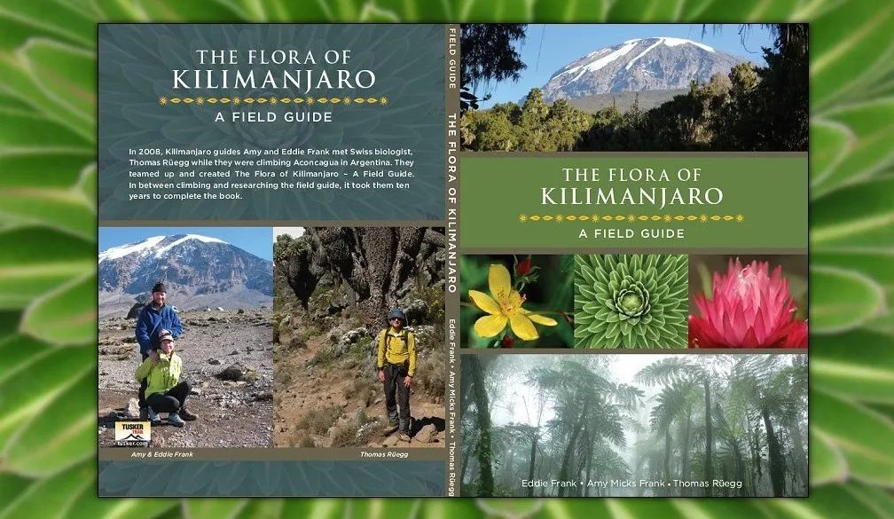
This is a classroom, a place to learn and during his 54 ascents in almost five decades, Tusker founder, Eddie Frank, has been a keen student of Kilimanjaro’s changing vegetative state. He has collaborated with Tusker’s own Amy Frank and botanist Thomas Ruegg to compile the first field guide to the flora Kilimanjaro.
Read about the remarkable Eco-zones you climb through on your Mt. Kilimanjaro adventure! Now you can have our guidebook in your pocket to enjoy these botanical wonders even more!
Get your copy here -> http://tusker.world/Kilimanjaro-Field-Guide
Magnificent Montane
Botanists and birdwatchers could spend their entire time on the mountain in the montane rain-forest because it is exquisitely primeval in its floral diversity and wildlife. It harbors Africa’s tallest indigenous tree, Entandrophragma Excelsum,stop beneath it as it soars nearly 200 feet. It’s a good place to rest, or get in out of the rain or for shade. As you look up you feel very small, but happy to be a part of primordial Africa. Relish the mist and rain because it nurtures the most bio-diverse Eco-zone on Kilimanjaro, and realize it took a mere million years to create this biologic cathedral.
The trail meanders upward and you sweat in this luxuriant hot house under veils of bearded lichen. When you see tropical blossoms stop and listen carefully for bird song. Scented tropical sweetness attracts the Crested Turaco, the most handsome bird on the mountain.
Lemon-scented Begonias, Impatiens, Albizia and Mimulus are abundant and if you were home you would pick a few and put them in a nice flower vase to impress your wife or girlfriend. Here they attract animal and insect life. By the time the day ends you’re at 9,200 feet and you’ve reached the forest’s border. Keep your binoculars handy as small game and several species of monkeys patrol the forest boundary.
Heath and Moorland
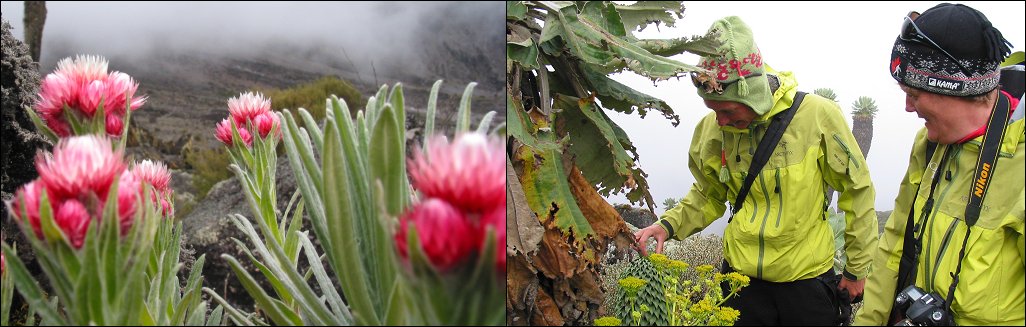
The next biodiversity chapter of your climb is other-worldly, a combination of grass lands, bogs and strange singular tall plants at an elevation reaching 13,123 feet. As you approach, 15 foot high Lobelias – silky gnarled heather that stand like green soldiers guarding their mountain castle armed with spiky red swords and a column of green rosettes. Your camera should be handy because the contrast here is great with once in a lifetime photo ops.
Surprisingly, many green things flourish here and if you look closely you find myriad flowering bulbs (red hot poker) and gladiolus. Buttercups fill the bogs, and Protea burst with cone shaped blossoms. This may be a botanist’s paradise but it is fragile so stay on the trail and use your binocs to study the flora and bird life.
Mutant Weed on the Volcanic Moonscape
By the time you’re well above tree line it is cold and windy between 13,100 and 16,400 feet. Plod through the boulder fields approaching the Barranco Wall, but keep your head up, you may be surprised amidst this grey volcanic moonscape. Ahead just under Barranco Wall lies one of the trip’s great surprises, a cluster of walking dead cactus-like trees some as high as 20 feet.
These are the endemic Giant Groundsel, also called the Giant Senecia (Dendrosenecio Kilimanjari). It only took a million years for these mutant weeds to evolve on Kilimanjaro, but it is worth the wait and your study time. These withered giants keep their dead leaves tethered to their trunk to self-insulate in the subzero nighttime temps. Their green leaves atop provide the only hint that this is a living plant and they close at night to protect against cold. Marvel at their adaptation but move swiftly to camp because summit day looms.
Arctic Ice Cap or Hanging Garden?
Welcome to the summit – you’ve made your goal. You never thought this freezing cryogenic chamber of melting ice could be so damn beautiful and uncomfortable. It’s the polar opposite to the montane forest’s hot house below.
We live in a world of shrinking glaciers and it’s evident as you enter the summit. With climate change Kilimanjaro’s diminished glaciers stir as many questions as they answer. Will the 60 plant species from the alpine desert migrate to the warming summit? When your grandchildren make this trek will Kilimanjaro’s summit become a hanging garden?
Kilimanjaro is an evolutionary cradle that continues to sway on the winds of change. Be focused on making the summit and when you do, celebrate with your fellow trekkers. You pushed your physical and mental limits to adapt to less air and severe cold. That effort made you felt so very alive! Relish it. And come back for more.